Categories
Final Project

Did Linn Have A Major Impact In The Battle of Roanoke Island?

My research question for this project was whether or not James Merrill Linn had a major impact on the Battle of Roanoke Island, or if he just seemed important because of his concise account. To discover the answer to this question, I wanted to compare the movements of Linn to the overall movements of the Union and Confederacy. If Linn happened to be in an important position during a turning point of the battle, he would be considered to have a major impact. I first read all of Linn’s diary entries from February 7th to the 12th, 1862. These entries gave me a picture of the Union’s as well as Linn’s positioning during these dates.

This is a picture of Linn's diary from the 7th.
This is a picture of Linn’s diary from the 7th.

Luckily, these entries had already been transcribed, so it was easy for me to decipher what Linn was saying. Without prior transcription, this process would have been very tedious and time consuming.

Next, I then used ArcGIS to map out the positioning of Linn and the Union, as well as the Confederates. This process was much more difficult because the maps from 1862 are not exact replications of what the land actually looked like. Men who had walked the island drew these maps from hand; therefore, there was slight error when looking at exact positioning of troops.

Screen Shot 2014-12-16 at 7.53.16 PM
This the map “Roanoke1862” with nothing on it. You can see the locations of the gunboats, forts, cannons, etc. very clearly.


To illustrate the different movements of Linn, the Union and the Confederacy, I gave each subject a color. Linn was represented by purple, the Union by blue and the Confederacy by red. This helped show just from a glance at the map that was moving where.

Linn's movements are represented by the purple dotted line. The Union's movements are represented by the blue dotted line.
Linn’s movements are represented by the purple dotted line. The Union’s movements are represented by the blue dotted line.

On the positive note however, these maps did provide a unique look into what the soldiers were seeing in 1862. This is very evident in the layer “Roanoke1862” because the locations of the ships, forts and guns were drawn onto the map. This especially helped the mapping process because it gave me the locations of different Union soldiers that Linn left out in his diary. For example, in the map below, you can see exactly where the Rebels surrendered. In Linn’s diary, he fails to mention the location of where the Rebels actually surrendered, just the location of himself when he heard the news.

Looking at the blue stickpoint, you can see where the Union takes over the battle. Looking at the blue rectangle, you can see where Linn's regiment was located.
Looking at the blue stickpoint, you can see where the Union takes over the battle. Looking at the blue rectangle, you can see where Linn’s regiment was located.

Upon completion of the map, I was able to see where Linn’s regiment was located during the actual land battle. This gave me good insight on his regiment’s importance to the battle, and whether or not they achieved any heroic actions. The 51st Pennsylvania (Linn’s Regiment) was located right along side the Rhode Islanders, in the bottom right corner of the Union’s positioning. This was very far away from the Confederate’s battery (as you can see in the map below). Looking closely, one can see that the Pennsylvania and Rhode Island regiments are in fact very close to each other.

The Rhode Islanders are located directly to the right of the 51st Pennsylvania (blue rectangle)

This is vital because Linn points out that much of the Pennsylvania regiment ends up getting intertwined with the Rhode Islanders. Though not intentionally, this is somewhat comical because while the battle rages on up ahead of them, Linn is worrying about which of his men became tangled up with the Rhode Islanders. This in turn supports my hypothesis of Linn not being very vital to the overall battle, he just happened to have a very detailed account.

 It was through the completion of this map that I discovered that all fighting had stopped on February 8th. This was surprising at first because Linn’s diary account of Roanoke Island lasts until the 12th. Upon further inspection, I was able to conclude that after the battle, Linn in fact traveled all over Roanoke Island. Whether he was completing menial tasks for the military, or just relaxing on the shore, Linn paints a picture of what he accomplished after the battle. Due to the fact that he was simply completing menial tasks, I at first did not find his travel on the island important. After looking intently into his positioning however, I realized that Linn was able to see the island in an entirely different way from the Confederates. Being the victor, allows one to really see the beauty of the land he is fighting on. While the Confederates were being shipped to prisoner of war camps, Linn was able to take in just how beautiful Roanoke Island is. He realizes this when sitting on the shore with Jim, George and Gibson, watching prisoners being transported to the ships.

In conclusion, ArcGIS is a fantastic tool to map out the Battle of Roanoke Island, while at the same time, look at the significance of Linn in the battle. I was able to see that while the battle was raging at the Confederate battery, Linn was in fact far behind, trying to assemble lost troops. Also, Linn was not in fact present when the remainder of the Confederate troops surrendered. He was notified by General Foster, who on horseback, ran into Linn and his regiment on their way back from the battery towards headquarters. Both of these examples solidify my hypothesis of Linn not having a major impact on the overall battle. We are assuming he had one because of his very in depth diary.

In order to see my web application click here: http://bit.ly/1wKZsy0


Citations

Linn, James Merrill. Diary. [February 7-12] 1862. MS. Bucknell University Archives and Special Collections, Lewisburg, PA.

 “Map of the Battlefield of Roanoke Id. Feb. 8th 1862 / | Library of Congress.” Map of the Battlefield of Roanoke Id. Feb. 8th 1862 / | Library of Congress. N.p., n.d. Web. 17 Dec. 2014. <http://www.loc.gov/item/99447476/>.

 “Map of Roanoke Island. [February 8, 1862]. | Library of Congress.” Map of Roanoke Island. [February 8, 1862]. | Library of Congress. N.p., n.d. Web. 17 Dec. 2014. <http://www.loc.gov/item/99447479/>.


Categories
Blog #5

Experiences While Mapping

In the past couple of weeks we have worked thoroughly with GIS. This has taught me a great deal about the digital world and how to convey it to the general public. For example, we learned how to create maps that represented the travels of Linn throughout his diary. With GIS, we are able to map Linn’s positions and see what he saw through different map layers. In my case, I used the map layer “RoanokeRebels” to plot Linn’s journey from the beaches of Reno all the way to Pork Point. I was able to visualize the various forts and land obstacles, as well as get a feel for the exact route Linn took to get to his destination. GIS creates a story out of just a few of Linn’s diary entries. This idea of mapping through GIS relates directly with Bodenhammer’s theory of spatial thinking.

Linn runs into a fellow soldier in this swamp who happens to also know James Merrill Linn
Linn and his comrades run into fellow soldiers in a swamp and stop to talk about past colleges, friends, etc. 

Spatial thinking is the way in which we navigate the world while manipulating the space around us. It is this type of thinking that has, “reinvigorated geography as a discipline, just as it has engaged scholars within humanities” (Bodenhammer, 14). More specifically, it has brought about what Bodenhammer calls “intellectual currents” into the American experience. GIS is a perfect example of how maps can provide a story in which anyone can follow. At the beginning of this assignment, I knew nothing about Roanoke Island and what battles had taken place there. However, through the process of mapping and what Bodenhammer calls, “observation and testing”, I have been able to develop a good understanding as to how the battle of Roanoke Island unfolded.

It doesn’t matter what the map is of or where it is, through spatial thinking with the right resources, we are able to comprehend any event in history. What’s so great about GIS is that it offers, “a view of the physical environment seemingly stripped of its cultural assumptions” (Bodenhammer, 16). This means that we are seeing the map as a plain canvas into which unlimited amounts of data are poured into it. Through the addition of map layers and map notes, the viewer is able digest what happened on that particular map, and can then proceed to make an inference on what occurred. Despite all these benefits of GIS, “most humanists have not adopted GIS, or more fundamentally, found it helpful” (Bodenhammer, 22). However, I believe that over time, people will start to realize the value of GIS and will learn to incorporate it more and more into their work.

Here is the link to my map project: http://bit.ly/1qv35c8


Categories
Blog #4

Close Reading At A Micro Level

In her article, “A rationale of digital documentary editions”, Elena Pierazzo claims, “the digital medium has proved to be much more permissive and so editors need new scholarly guidelines to establish ‘where to stop’.”(463). By digitally analyzing text at a micro level, I have been able to look into aspects of the manuscript that I wouldn’t have done otherwise. For example, I’ve learned to take note on which specific words the author tends to use, in what way the author tends to describe people and places, and even observe the author’s past experiences, and how that in effect can make an impact on their writing.

Nobody looks at a text close enough for full understanding until he or she has completed a transcription of that text. In the beginning of this assignment, I knew very little about Linn and his travels just from reading his diary. However, now that I have meticulously gone into detail transcribing multiple entries of his diary, I am able to connect with Linn on a level that I wasn’t able to before. The action of transcribing has caused me to engage with Linn’s diary and help me discover aspects of his writing that I never would have noticed before.

Color coding words helped me think about which words to mark up and why

What is interesting about transcribing a document is that everybody will do it a different way. Pierazzo states on page 465 that, “if every editor necessarily selects from an infinite set of facts, it is evident that any transcription represents an interpretation and not a mechanically complete record of what is on the page.” This is why it is impossible to exactly replicate the document in a transcription; it is subjective to the person transcribing it. What’s good about this is that one can see how engaged a person is with the material by looking at how marked up the document they’re transcribing is. Because everybody transcribes differently, it becomes evident who is focusing on what aspect of the text through his or her transcription. This in turn gives a well-rounded view of the document as a whole, and one will be able to look into multiple aspects of the document with ease.

Oxygen shows the tags within the diary entry

Pierazzo couldn’t have said it better when she stated, “The preparation and publication on the Web of digital scholarly editions, especially those based on transcriptions of manuscripts, are at the centre of lively debate among scholars.”(463). Though we are considered more of students than scholars, I would wholeheartedly agree with Pierazzo on this point. As a class, we have had multiple discussions on whether certain things are objects or places and event versus time. Personally, I believe these discussions are the most beneficial part of the transcription process because it allows everybody to hear different perspectives. To resolve our disputes, we would vote, majority winning. However, before that vote was made, each side would have to give an appealing argument to support their claim. This kind of action in class made for a very productive work environment, and helped bring about discussion that benefitted everyone.

Categories
Blog #3

Blog Post 3: The History of Chronology

Throughout history, the ability to get chronology correct has been vital. Grafton states, “For Christians, getting chronology right was the key to many practical manners…” (1). It is after using Timemapper that I can truly appreciate how writing needs to be represented in a form that can easily depict change over time. What is Timemapper one may ask? Timemapper is an online tool that is used to piece together timelines in which one can choose the duration. For example, our class chose the 1860’s as an ideal time to create a timeline, thus resulting in the emergence of events I never knew happened in that time period.

What Timemapper does better than just a regular time line is that it puts a visualization of the event into the viewer’s head. Picturing time through just words on paper is a very difficult task. As Grafton points out on page 10, “…we typically see them as only distillations of complex historical narratives and ideas.” But, through an interactive timeline with pictures, we are able to comprehend events at a faster rate than if we were just looking at words on paper. For example, we can look deeper into an issue such as the publishing of Twenty Thousand Leagues Under The Sea while at the same time; see the impact of Alice in Wonderland in the 1860’s society. Timemapper helps give the viewer a short summary of the event and put a picture into that viewer’s head.

Screen Shot 2014-10-05 at 9.42.28 PM
Timemapper summarizing Twenty Thousand Leagues Under the Sea

In his essay, Grafton also talks about Priestley’s invention, the Chart of Biography. “Among the most important events of this period was the publication in 1765 of the Chart of Biography…” (Grafton, p. 19). This chart, revolutionary for its time, revealed the dates of birth and death of historical figures. In conclusion to this chart, Priestley and other theorists firmly believed that a linear timeline does not in fact help the user comprehend the information. Priestley’s chart was the first of its time and set the benchmark for timelines leading all the way up until today.

1765 version of The Chart of Biography


Categories
Blog #2

Blog Post 2:Making Inferences and Drawing Conclusions

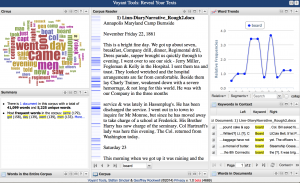
While trying to discover the validity of Professor Jakacki’s hypothesis, a new question came to my mind regarding the words “board” and “Cossack.” I want to know how closely “board” and “Cossack” correlate to each other in Linn’s writing and whether or not Linn uses these words more when on land or out at sea. To discover these questions, I will plug both words into Voyant (http://voyant-tools.org/).

To start solving my questions, I’m going to first plug in “board” to the Cirrus. After doing this, one can see that “board” appears 69 times. By looking at the corpus reader, one can see where in the text “board” is most frequent. Taking a peek to the right of the screen at the words trend panel, one can tell that the usage of “board” tends to spike in segments 4,5 and 7. These spikes are on January 6th, January 25th and February 9th (a Sunday to be exact). One must also remark on the sharp drop that the usage of “board” experiences in segment 6 (February 6th), which is between January 25th and February 9th.

Screen Shot 2014-09-24 at 1.40.18 PM

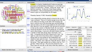
To completely answer my question, I must not plug “Cossack” into Voyant and look for the correlation. Cossack appears 46 times throughout the diary, and tends to have the same frequency of appearance as “board.” To me, this is not a surprise because both words have to do with ships and more likely than not, when Linn is talking about ships, he is probably talking about the Cossack. The Cossack experiences its spikes on January 6th (segment 4) and February 9th (segment 7). The only difference between the two words is that the largest decline in usage happens on January 9th (segment 3).

Screen Shot 2014-09-24 at 10.07.19 PM

After looking at both words in Voyant, I can now see that there is a strong correlation between “board” and “Cossack”. On top of this, the usage of these words spikes when Linn is onboard a ship (most of the time it is the Cossack). There are many reasons behind this. In my opinion, Linn tends to use words regarding ships when he is in fact on the ship. However, there are many possible reasons as to why Linn does this (mood, weather, time of day). The only real way of knowing would be speaking to Linn himself.