Categories
Final Project

Linn vs. Third Party Sources: The Battle of South Mills

Was James Merrill Linn accurate in his descriptions of his experience in the Battle of South Mills?

The Battle of South Mills

My research question was to find out if James Merrill Linn’s diary transcriptions were a legitimate primary source of information on the Battle of South Mills. To give background information to my audience, I started with my own diary entry date of April 17-18,

Layers from my previous map

1862. I added these map notes to my new map of the Battle of South Mills. During this time, Linn left New Berne, stopped at Hatteras on Roanoke Island, and left for Elizabeth City. This is where I used transcriptions from Julia and Riz, who transcribed the actual battle. Using arcGIS, I mapped out exactly what Linn was writing to the best of my abilities. I used the color green to document anything Linn wrote in his diary to keep it separate for the next step in my research project. During this segment, I did not look at outside sources, besides a couple maps, in order to keep myself zoned in on Linn’s account of what was happening.

Working on web map
Working on Web Map

After mapping out Linn’s version of the Battle of South Mills, I searched for third-party sources that could give me more of an idea of what happened. Using objective sources allowed me to focus on the big picture of this battle and not just what Linn wrote in his diary. When utilizing these sources, I focused on the Pennsylvania 51st Regiment. This was Linn’s regiment, so I assume Linn was with these other soldiers. Gaining more knowledge about the Linn regiment’s whereabouts during this battle made allowed me to gain more insight to what Linn could have been talking about. Also, I wanted to contrast what Linn claimed in his diary to what these other sources claimed. I also mapped out the third-party’s account of the Battle of South Mills and the Pennsylvania 51st Regiment. When mapping this out on arcGIS, I used a new layer and used the color yellow to make all of the pushpins, lines, arrows, etc. This allowed me to see clearly both accounts of the Battle of South Mills.

Finished Map (Showing Green and Yellow)

When the Battle of South Mills was mapped out according to both perspectives, I created a web mapping application. Here, I chose the story template. At first I had a few slides to show the background information on the battle. Once I got to the actual battle, I switched between Linn’s claims and the third-party source’s claims. I utilized the zoom tool and tried to make this part of the project the most user-and-reader friendly. I added pictures of some of the maps that I found on my outside sources that really helped me visualize this battle. Because it happened over 150 years ago, there are not many official accounts of this battle. Technology was not exactly up to par. However, studying many hand-drawn maps of the Battle of South Mills allowed me to get a pretty good idea of how this battle played out.

Working on Web Mapping Application

I decided to narrow down my focus to just actions Linn and his regiment took. I did not want to complicate this research question by adding in emotions, causalities, etc. I took a very objective view while mapping out the Battle of South Mills. This made everything much cleaner and efficient when using the web map and later the web map app. Another “blessing” to me was a website Riz found on the internet called “Battle of South Mills.” It had an abundance of hand-drawn maps of the battle. Also, it was interesting to see some of the artifacts of the battle. Another person’s perspective I payed close attention to while mapping the third party sources’ version of the battle, was that of Lieutenant Colonel Bell. He referenced Linn’s Regiment, Pennsylvania 51st, many times. Whenever I saw something that mentioned Linn’s regiment I was payed extreme attention to it.

Finished Web Mapping Application

Ultimately, arcGIS was a great tool to use to map out the Battle of South Mills. I think it is very user-friendly and anyone would be able to use the web mapping application. I was able to take James Merrill Linn’s diary entries and compare them to third party sources to see his accuracy. At the end of this project, I was not able to completely decide if Linn is an accurate historical storyteller, because I only researched one battle. In my case, I think Linn was a somewhat reliable source. Besides for some minor contrasts in documentation of the battle, it is hard to tell which source was correct. I was only able to find one website that had other sources and account of the Battle of South Mills. I am not even sure how factual that website is. My research question could not sufficiently be answered with this one project.

Citations

“Battle Summary.” Battle of South Mills. Ed. Bruce Long. 10 Apr. 2010. Web. 14 Dec. 2014.
Civil War Cannon. Digital image. Mediad.publicbroadcasting. Web. 16 Dec. 2014. Linn. Digital image. Diane Jakacki. DianeJakacki.net. Web. 16 Dec. 2014.
Civil War Fence. Digital image. Big Stock. Web. 16 Dec. 2014.
Currituck Beach Lighthouse. Digital image. Currituck Beach Light. Web. 16 Dec. 2014.
Currituck Courthouse. Digital image. Appox. Web. 16 Dec. 2014.
Cypress Swamp Along Pasquotank River. Digital image. Champiii. 5 May 2014. Web. 16 Dec. 2014.
“Eastern Coast.” Eastern Portion of the Military Department of North Carolina. S.l. 1862. Print.
Hatteras Island. Digital image. Ocean Front Hotels. Web. 16 Dec. 2014.
Historic Old Jail in Currituck. Digital image. Albemarle Commission. Web. 16 Dec. 2014.
Mouth of Pasquotank River. Digital image. Api.ning. Web. 16 Dec. 2014.
Museum of the Albemarle. Digital image. Battle of South Mills. Bruce Long. Web. 16 Dec. 2014. Operations in North Carolina. Digital image. Battle of South Mills. Bruce Long. Web. 16 Dec. 2014.
Shenandoah 3. Digital image. Tom McMahon. Web. 16 Dec. 2014.
Sneden, Robert K. “Plan of Battle of South Mills.” 1862. ArcGIS. Web. 16 Dec.
2014.
“South Mills Battle.” ArcGIS. Web. 16 Dec. 2014.
The Battle of Camden. Digital image. Battle of South Mills. Bruce Long. Web. 16 Dec. 2014.
The Battle of Camden: Plan of the Battlefield. Digital image. Battle of South Mills. Bruce Long. Web. 16 Dec. 2014.

Categories
Blog #5

Linn’s Journey from New Bern to Roanoke Island to Elizabeth City: Map and Web App

Linn's Journey from April 17 ,1862 to April 18, 1862
Linn’s Journey from April 17 ,1862 to April 18, 1862

In the past couple of weeks, we have used ArcGis as a form of technology. First, we were instructed how to use the maps,create layers, and add map notes. After doing this, we could create our own maps and upload archival maps to help us see the same landmarks Linn saw in 1862. I specifically chose the map “Eastern Coast” to help me see New Bern, Roanoke Island, and Elizabeth City a little bit more clearly as it was in the mid-nineteenth century. After creating our own maps with map notes and layers, we, then, created an app. This allowed us to show multiple diary entries basically as a story. We could take our audiences, interactively, through Linn’s diary entries and show them where Linn was and what he did. This map layer “Eastern Coast”, however, turned out to be very grainy, so I only used it when necessary and did not need to be zoomed in.

In the article, there is a crucial point: “through observation and testing we are able to understand how the world operates” (Bodenhammer). We saw the maps of where Linn’s journey and diary entries take place, but, until we can physically make our own maps and “test” things out, we cannot fully experience Linn’s perspective. GIS really helps us be present in his diary entries. We are essentially re-living what Linn did. We are trying to, using different aspects of technology, to better get an understanding of this soldier’s life during the Civil War.

The only time I have ever heard about Roanoke Island was in history class. We learned that this was the “lost colony.” After hearing Linn mention Roanoke Island, my mind had drifted back to history class, because this was my personal interpretation of the island. As Bodenhammer writes, “two people who view the same object may interpret it quite differently based on their different assumptions and experiences” (Bodenhammer). Linn had a very interpersonal experience with Roanoke Island, and, I am guessing, he never even thought about the fact it was called the “lost colony.” He may have heard about it, but that is not what comes to his mind when he hears the island’s name.

At the end of the day, “gis is fundamentally what happens in a geographic space” (Bodenhammerr). It is as simple as that. It allows us to take what we have read and be able to visualize it in a way that makes us more aware of what is happening in certain situations. I have never heard of New Bern or Elizabeth City, but GIS helped me understand exactly where Linn was and the encounters he had.

Categories
Blog #4

Oxygen Mark Up of Diary 60

During the markup process of my Linn diary transcription, I learned a lot about the context of Linn’s writings through close reading. It allowed me to focus on certain words that helped me get a greater understand of the t text as a whole. Even collaborating with the editorial group in class helped me get a better grip on how to mark up certain words. One such instance that helped me decide what to mark certain words was the debate over whether a boat is a place or an object. In my opinion, I believe a boat is a place; it is extremely the case when it is named like the “Cossack.” The “Cossack” seemed to have much more of a meaning and presence than just an object. After a lengthy and intense discussion on why our class felt what they felt, we decided to mark up any boat, regardless of a proper noun, an object. We decided that this “object” would have a more descriptive mark up.

How do we mark up a boat?

Elena Pierazzo really categorizes the, in Jakacki’s words, “richness of the marked up text as a form of intellectual engagement with its interpretation.” In her article, “A Rationale of Digital Documentary Editions” is exemplary of how people should mark up transcriptions. One way she wants people to consider the marking up process is to have “have limits, and limits represent the boundaries within which the hermeneutic process can develop”(Pierazzo). Basically, she believes that we cannot mark up and focus on every single word. That would one, very time-consuming, and, two, counterproductive. In order to interpret Linn’s transcriptions, we had to make decisions on what was important to us. If everything was marked up, wouldn’t we just end up at the beginning? We need to see the relationship between certain things and this is, ultimately, intellectual engagement.

Screen Shot 2014-10-22 at 5.43.25 PM
persName and placeName

Another point that Pierazzo brings up is that we ultimately choose what we rant to represent. There needs to be a meaning behind the mark ups. She states that “the process of selection is inevitably an interpretative act: what we choose to represent and what we do not depends eitherr on the particular vision that we have a particular manuscript or on practical constraints”(Pierazzo). There are certain influences that make us mark up certain words. In my case, I focused on people and places. What I found was that after zoning in on one particular area, I could then go deeper and mark up those words even further. While having some technical difficulties in the level I could describe different people’s roles, I at least was trying to make that one of my main goals.

The last crucial point that Pierazzo argues is that letters are not just marks on a paper. They are symbols we chose to make meanings for. Robinson insists, “‘an ‘i’ is not an ‘i’ because it is a stroke with a dot over it. An “i” is an “i” because we alls agree that it is an ‘i’’”(Pierazzo). Taking this into consideration, our class decided that we would always use “&” for every time Linn uses “&.” After coming to this conclusion, we had to make it clear in Oxygen that we wanted “&” to also mean “and.” An ampersand is not just some weird symbol, we came to a final conclusion, along with the English society, that an ampersand means and.

After using Oxygen and reading the Pierazzo article, I really have a better understanding for Diary 60 of the Linn transcription. Close reading individual words contributes to the overall meaning of Linn’s diary.

Categories
Blog #3

What is Time?

After using TimeMapper to document major world events of the 1860s, I have seen how chronology of events contributes to linear and non-linear time. It is a user-friendly tool that allows one to fill out the form of the even he or she wants to create. It is then documented in a google doc and is placed into the timeline. We used this tool to see what events were happening in the 1860s that could relate to James Merrill Linn in the winter of 1862.

Florence Nightingale Finds the First School of Nursing

One very interesting fact that Grafton brings up is that Chart of Biography, published in 1765, was revolutionary in that itintroduced chart that is recognizable to most of us today. This chart was a a series of horizontal lines indicating when and how long famous figures lived. Priestly’s chart was one of the first non-linear time maps. Our TimeMapper experiment was a new rendition of this simple concept. It shows how two unrelated events, such as: Florence Nightingale’s first nursing school and James Merrill Linn enlisting in the war, really do have a relationship. Clearly, if this was only the first nursing school, the medical health system was lacking. This definitely must have had an effect on Linn and his fellow troops.

First Machine-Powered Submarine Photograph


Grafton brings up the point that technological advancements, such as photography, had an impact on documenting history. In our TimeMapper assignment, every one of the events of the 1860’s had a photo and geographical coordinates. These ammedities make it easier to relate the historical events to Linn’s situation.


On figure 14 in the reading, Grafton references “The Long Now Foundation, comparative time scales of the concept of long.” Linn, in the winter of 1862, is documenting the “now.” When we used TimeMapper, we were documenting the “nowadays.” Linn’s writing focuses on yesterday, today, tomorrow, while our research this past week focuses on more on an entire decade. Why would Linn reference the publication of Les Miserables? He is writing with a different concept of time. He is living in the “now.”

Categories
Blog #2

Can Distant Reading Prove Hypothesis?

With respect to Professor Jackacki’s hypothesis about James’ perspective, I have used Voyant tools to attempt to either affirm or deny that James shows a loss of innocence roughly halfway through our class transcription. The words I decided to utilize during my distant reading instilled upon me new questions.


Screen Shot 2014-09-24 at 1.37.51 PM 
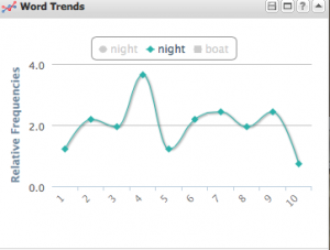
The first world I selected was “night.” This word appears 82 times throughout the text. As I clicked on the word in cirrus tool and viewed it on the word trends tool, I did not notice any patterns whatsoever. Especially during the time period Dr. J. addresses, there was a consistent frequency of the number of times night was used. It also did not appear to be too much different than the beginning diary transcripts, either.  Distant reading using this word alone, did not help with Professor Jackacki’s research question.


Screen Shot 2014-09-24 at 1.38.10 PM
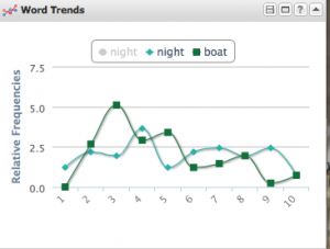
However, when I added a second word, “boat,” I noticed a distinct interesting. I noticed these two trends were almost mirror images of each other. There seemed to be a negative correlation between talking about night and talking about boats. Whenever Linn was talking about a boat, typically the Cossack, he did not seem to be mentioning night. This leads me to the question: when Linn is on board the Cossack, is he writing at night, therefore he does not mention night, or does all the action seem to talk place during daylight hours? Why does is there this strange relationship between “boat” and “night”?


These two words do not necessarily reveal anything about Linn’s experience in battle. I just know that when talking about his boat, the Cossack, does not seem to have a correlation to his innocence or lack thereof. This plays out to be true when Linn mentions night. Unfortunately, I was unable to affirm or refute Professor Jackacki’s research question and hypothesis; yet, maybe other words will be able to. They do guide me towards the thought that Linn may have a pattern of the time he rights his diary entries.

I benefitted from using Voyant tools and feel that once I am able to come up with a better research question, I will be more successful with the program. Distant reading is a very intriguing concept and, although I was “unsuccessful” with the goal of getting to some type of conclusion over the accuracy of Professor Jackacki’s hypothesis, I have used this as an experience that can improve my skills in this field.