Walk in Linn’s shoes with GIS

Screen Shot 2014-11-19 at 10.22.01 PM

Map of Roanoke Island with GIS

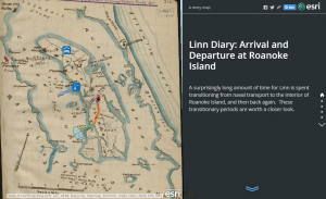
GIS, Geographic Information System, helped us visualize the life of James Merrill Linn and the Civil War by showing us the travel path he took. Throughout the class, we have been introduced to different techniques which people have used to decode a text and learned to derive information through various means: TEI, TimeMapper, Voyant Tools, Transcribing. This tool is the most effective so far. It allows us to see many layers of information letting us to obtain a lot more informations. We are able to see it in geographic form and displaying informations including time and context.

Bodenhamer says “We recognize our representations of space as value-laden guides to the world as we perceive it” (14). We often associate ourselves with where we are from and where we have been. Locations has always been an important of our lives. Being able to see Linn’s experience in terms of location and path, we are able to integrate more information than we could with  other kind of representations. With the help of GIS, we can display the location, time, and context of these events.

In my experience with GIS, using a layer for the concentration of slaves in the United States in the 1860s and the battle won by the North, I was able to estimate the location for the 19 contrabands’ origin. In the diary, Linn says  “a small boat came in, said to have had on board 19 contrabands, who escaped from above Roanoke — 5 women & a baby”. From seeing the concentration of battles won by the North close to Roanoke, we are able to see its correlation with the escape of the slave.

Screen Shot 2014-11-19 at 10.23.38 PM
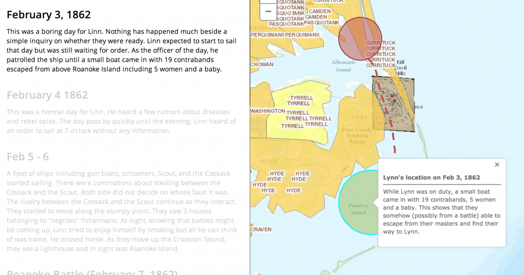
“Evidence about the world depends on the perspective of the observer” (19). In the diary, Linn mentioned that the gun boats went between Tyrrell Shore and Roanoke Island. As we can clearly see, Tyrrell is the slave concentration area which is far from Roanoke Island. Without the help of GIS, we would not have question Linn’s directional sense. This ,however, can also means that the maps they had back then was not accurate. The answer to this is not important but what important is the question itself. Without GIS, we would never have come up with this hypothesis and therefore another piece of information.

Bodenhamer says “visualize a spatially accurate physical and manmade environment that proved the attraction” (21). We were able to walk in Linn’s shoes. He noticed sightsee, he observed the shore and the lighthouse, He had a smoke at night. Seeing how close he was to the battle, we can have a close reading on his personal life.

Link to Map: http://bit.ly/1t6CIEDScreen Shot 2014-11-19 at 11.12.44 PM


Linn’s Narrative as Revealed By GIS

GIS or Graphic Information System, is a quantitative method for parsing vast amounts of information in  geospatial context. For the case of James Merrill Linn and his 1862 experience in the Civil war, GIS allows us to give spacial context to his narrative. The existence of certain topological features, distances covered and object encountered all have a vital effect on Linn’s experience. All of this information can be neatly organized in the form of a highly interactive and flexible map. We can mark Linn’s journey through space and give detail to the characteristics present. As Bodenhammer points out, GIS and more generally viewing history through a spatial lens is a fundamental shift in the way history is understood (15). Bodenhammer claims that with a periodic or chronological analysis, certain details can be lost, a recent shift accompanying GIS towards a space includes many benefits. Any region of space has a multitude of inherent characteristics vital for historical understanding.  Bodenhammer writes, “Spaces are not simply settings of historical action but are a significant product and determinant of change…all spaces contain embedded stories about what happened there.”(16) In a general sense this means that spatial thinking elucidate the complexities of history as they are vital actors in historical events. Spaces are embedded with the cultural codes of whatever political arrangements took place. For example, as pointed out by Bodenhammer,  the descepency between European settlers who saw the North American continent as a wilderness, a resource to be consumed and the Native Americans who saw it as home (16). With this information and other historical sources like maps and written observation we can attempt to rebuild a world lost to time.


The question remains, is GIS in fact a source of objective knowledge or simply a method of interpretation? Bodenhammer claims that GIS is not simply a method but the incorporation of diverse forms of data reveal new information as an emergent property.  Does GIS provide an empirical truth or simply the view  of an observer? Bodenhammer acknowledges issues, ” Knowledge was always contingent on the perspective of the observer. Even calculations of the material world depended upon cultural assumptions.” For example, when is a river a creek or a brook? When is a pile a mound and when is it a mountain? As a response Bodenhammer points out that regardless of name, the object and its nature remains the same, through the nature of GIS we can introduce rigid definitions that are flexible through continually evolving technology, preserving some state of objectivity and reducing cultural artifacts (18).


As for Linn, GIS provided many advantages in understanding his narrative. For example, I was surprised by the length and nature of the distances between known location that Linn had to cross. Current physical and historical maps revealed the nature of the terrain covered, including swamp, and thick woods. My page of Linn’s diary heavily featured a state of exhaustion, seeing  the path Linn took it is easy to understand his condition, a spatial understanding of Linn’s world was necessary for the contextualization of this knowledge.


App: http://bit.ly/1AkX0lA

Linn’s Connection to Roanoke Island: Using GIS

Humans often think in terms of space: where things are, how far apart, in what direction.  When examining a story, whether it be real or fictional, mapping out a spatial representation of the events can be a powerful tool in understanding deeper meanings and reasons.  As Bodenhammer explains it, “space offers a way to understand fundamentally how we order our world” (14).

Many of the decisions we make every day are greatly dependent on how we examine the space around us.  This was no different for people living 100 or 1000 years ago.  When we look at historical recordings, the reasoning behind many actions can be lost or go unseen, simply because we can’t see what they saw.  However, using GIS mapping, historical maps,  and other visual tools, we can recreate, to some extent, the world that these historical figures lived in.  By examining these maps and other visuals, we gain a better understanding of the circumstances and influences that led people to decide on the actions they took.  Bodenhammer mentions the example of the discovery of the New World (14-15).  It’s hard for us to imagine the allure of this land to the European countries 500 years ago because we know this place as our home.  However, historical maps and paths of the journeys of explorers let us see the vast open expanse that existed here.  Combine that with maps of population growth and religious turmoil in Spain, France, and England, and we can start to see the circumstances that led to the era of colonization.

Working in this way with Linn’s diary led to many interesting revelations.  The GIS mapping I did of his arrival to and departure from Roanoke island revealed a number of things about his experiences.  For instance, in his diary entry on February 7th, he mentions having to walk through a swamp to reach the rest of the regiment after making shore on the island.  With Linn’s short description, it was impossible to determine just how long he spent traversing these wetlands.  However, by drawing the path between the landing point and the regiment using GIS, I was able to see that most of that 2 mile journey was through swamp.  Once arriving at camp, Linn seems in a rather negative mood.  The difficulty that this march must have presented would explain his feelings at the time.

Bodenhammer describes a potential use of GIS technology as creating a myriad of different layers on a map, where each one “would contain the unique view over time – the dynamic memory – of an individual or a social unit” (27-28).  I think it would be very interesting to see what we could make of journal entries of different people with connections to Linn.  The personal stories of Beaver or General Reno could provide us with more insight into the things Linn didn’t write down, how these people were connected, and where their paths crossed and diverged.


Linn Diary  Arrival and Departure at Roanoke Island

Linn’s Journey to South Mills through Mapping


Reading and transcribing the diaries of James Merrill Linn and even analyzing them helped a bit with understanding the text, but what we have done recently helped even more. Mapping out his diaries allowed us to visually comprehend where Linn went and how it related to the events occurring at the same time. Through ArcGIS I could map out where Linn travelled in my particular diary entry, April 18-19, and get a clear view of Linn’s participation in the Civil War.

Screen shot 2014-11-19 at 9.58.12 PM

Linn’s Journey to Battle at South Mills

From the text I could think about the places where he went, but I had no idea what it looked like mapped out, and I couldn’t fill in the blanks about where he went and in what time period. I knew that he somehow travelled from the Pasquotank River to Currituck and then to the battle at South Mills but I did not know through what route. I also did not realize until I mapped it out that Currituck is so far out of the way, I thought it would just be in a straight line to the abttle. Through ArcGIS it was easy to see the route Linn and other soldiers took to get to South Mills. ArcGIS is a geographic information system used for working with and creating maps. It is such a good tool to use because “stories are both individual and collective, and each of them link geography (space) and history (time)” (Bodenhamer, 16). ArcGIS allows you to connect where something took place and when, and create a map using both of them. Although “the humanities and social sciences especially have advanced new lines of inquiry characterized by a different and more nuanced understanding of space…” (Bodenhamer, 15) and this tool works so well in the humanities department like in our situation, it can be used in other subjects too. “Archaeologists came early to GIS… Maps of uncovered human habitats, long a staple of the archaeologist, were easier to chart with the survey-based techniques of GIS. Artifacts bore a spatial relationship that was important in interpreting the past…” (Bodenhamer, 21). It’s easy to relate our experiences of trying to figure out where Linn travelled and when to uncovering human habitats for archaeologists. We are both just trying to connect geography and history to map out where everything took place in relation to another.

I really like that through GIS, there is a more set map of where Linn travelled. Without this technology, it would just be left up to each of us to interpret the diaries our own ways. However, using this tool, it allowed us all to map out where Linn definitely wrote that he was. Whether that is true or not all depends on the accuracy of Linn’s writings. Unfortunately, critics of GIS claimed that “evidence about the world depends upon the perspective of the observer, a distinction that GIS obscured. Two people who view the same object may interpret it quite differently because of their different assumptions and experiences” (Bodenhamer, 19). Personally, I think this is a good part of GIS because it is left up to facts and evidence, not opinions and assumptions.


My Web App:

http://bit.ly/1uyX6RD

Experiences While Mapping

In the past couple of weeks we have worked thoroughly with GIS. This has taught me a great deal about the digital world and how to convey it to the general public. For example, we learned how to create maps that represented the travels of Linn throughout his diary. With GIS, we are able to map Linn’s positions and see what he saw through different map layers. In my case, I used the map layer “RoanokeRebels” to plot Linn’s journey from the beaches of Reno all the way to Pork Point. I was able to visualize the various forts and land obstacles, as well as get a feel for the exact route Linn took to get to his destination. GIS creates a story out of just a few of Linn’s diary entries. This idea of mapping through GIS relates directly with Bodenhammer’s theory of spatial thinking.

Linn runs into a fellow soldier in this swamp who happens to also know James Merrill Linn

Linn and his comrades run into fellow soldiers in a swamp and stop to talk about past colleges, friends, etc. 

Spatial thinking is the way in which we navigate the world while manipulating the space around us. It is this type of thinking that has, “reinvigorated geography as a discipline, just as it has engaged scholars within humanities” (Bodenhammer, 14). More specifically, it has brought about what Bodenhammer calls “intellectual currents” into the American experience. GIS is a perfect example of how maps can provide a story in which anyone can follow. At the beginning of this assignment, I knew nothing about Roanoke Island and what battles had taken place there. However, through the process of mapping and what Bodenhammer calls, “observation and testing”, I have been able to develop a good understanding as to how the battle of Roanoke Island unfolded.

It doesn’t matter what the map is of or where it is, through spatial thinking with the right resources, we are able to comprehend any event in history. What’s so great about GIS is that it offers, “a view of the physical environment seemingly stripped of its cultural assumptions” (Bodenhammer, 16). This means that we are seeing the map as a plain canvas into which unlimited amounts of data are poured into it. Through the addition of map layers and map notes, the viewer is able digest what happened on that particular map, and can then proceed to make an inference on what occurred. Despite all these benefits of GIS, “most humanists have not adopted GIS, or more fundamentally, found it helpful” (Bodenhammer, 22). However, I believe that over time, people will start to realize the value of GIS and will learn to incorporate it more and more into their work.

Here is the link to my map project: http://bit.ly/1qv35c8