Categories
Blog #5

Linn’s Connection to Roanoke Island: Using GIS

Humans often think in terms of space: where things are, how far apart, in what direction.  When examining a story, whether it be real or fictional, mapping out a spatial representation of the events can be a powerful tool in understanding deeper meanings and reasons.  As Bodenhammer explains it, “space offers a way to understand fundamentally how we order our world” (14).

Many of the decisions we make every day are greatly dependent on how we examine the space around us.  This was no different for people living 100 or 1000 years ago.  When we look at historical recordings, the reasoning behind many actions can be lost or go unseen, simply because we can’t see what they saw.  However, using GIS mapping, historical maps,  and other visual tools, we can recreate, to some extent, the world that these historical figures lived in.  By examining these maps and other visuals, we gain a better understanding of the circumstances and influences that led people to decide on the actions they took.  Bodenhammer mentions the example of the discovery of the New World (14-15).  It’s hard for us to imagine the allure of this land to the European countries 500 years ago because we know this place as our home.  However, historical maps and paths of the journeys of explorers let us see the vast open expanse that existed here.  Combine that with maps of population growth and religious turmoil in Spain, France, and England, and we can start to see the circumstances that led to the era of colonization.

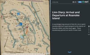
Working in this way with Linn’s diary led to many interesting revelations.  The GIS mapping I did of his arrival to and departure from Roanoke island revealed a number of things about his experiences.  For instance, in his diary entry on February 7th, he mentions having to walk through a swamp to reach the rest of the regiment after making shore on the island.  With Linn’s short description, it was impossible to determine just how long he spent traversing these wetlands.  However, by drawing the path between the landing point and the regiment using GIS, I was able to see that most of that 2 mile journey was through swamp.  Once arriving at camp, Linn seems in a rather negative mood.  The difficulty that this march must have presented would explain his feelings at the time.

Bodenhammer describes a potential use of GIS technology as creating a myriad of different layers on a map, where each one “would contain the unique view over time – the dynamic memory – of an individual or a social unit” (27-28).  I think it would be very interesting to see what we could make of journal entries of different people with connections to Linn.  The personal stories of Beaver or General Reno could provide us with more insight into the things Linn didn’t write down, how these people were connected, and where their paths crossed and diverged.


Linn Diary  Arrival and Departure at Roanoke Island

Categories
Blog #5

Mapping and the Battle of Roanoke

Although it took my a while to understand the program and how it all works, i found mapping to be incredibly useful and it allowed me to pull out a deeper understanding of what my diary entry truly means and how it connects to the war. Mapping itself is a very useful tool, and the ways that we utilized ArcGIS was very interesting. Although it took my a while to understand all the features, it allowed me to create a more interesting and compelling final product. Mapping allowed me to see what my diary was talking about in an easier context, by showing the course of the battle and his movements on an historical map. My mapping assignment allowed me to directly understand what effect my individual entry had on the war. Once i saw the historical map that was geo rectified on the the larger map, i was able to dissect my entry and see how his movements played out. Although it was hard for me to make conclusions from the basic writings of his diary, pulling out key phrases was what helped me in the long run. Little comments such as “He said he had been in pineswamp, but this was worse” and “Here we had to wade a pond up to our middle,” allowed me to make conclusions about where he moved around the map. GIS allows people to make a “more complicated story than traditional methods allowed,” (Bodenhamer) and thats exactly what i tired to do with my map. By combining the historical map and the entry, my story became stronger.

Looking at the historical map, a few things stuck out to me. My map notes below are without the historical map underneath it because it does not show up on my laptop, so i will have to explain. The battery image that comes up on the map is almost identical to the hand drawn sketch from Linn, as well as the location of the swamp in correlation to how he talks about his path to the battery. Although it may have seemed easy to me, its important to realize how perspective plays into all this. As Bodenhamer says, “the same body of water flowing in a channel may be called a brook, stream, or river.” This quote shows the importance of perspective, and it is important because someone else may have interpreted Linn’s writing in a different way from me. I made conclusions about the pineswamp and the pond, but they were not specifically talked about in the diary. Because of this, someone else may look at his path differently than i did.

Screen Shot 2014-11-19 at 5.37.57 PM
my map notes without the historical map
Capture
the battery from my entry


All in all, the practice of mapping allowed me to gain a deeper understanding of the way that Linn records history and how maps can help us gain a better understanding of how history works. By using this software, i was able to figure out “what happens in a geographic space” (Bodenhammerr), which in my case, is the island of Roanoke and specifically my battle field.  Just by looking at the historical map and re reading my diary, i was able to make incredible conclusions about my entry. Mapping for me was useful and interesting, and i think that it is something that i would be interested in pursuing as a final project if i found information that fit well into a mapping situation.

http://bit.ly/1EVI9O8

Above is the embedded code to my map