Categories
Final Project

The Reliability of the Linn Diary

All of the work that we have done in this course has focused on the Diary of James Merrill Linn.  During our time together this semester, aside from just learning the skills and tools of digital humanities research, we also developed a working knowledge of the Burnside Expedition, and the Civil War as a whole.  As a final project, I wanted to determine if our new historical knowledge was based on reliable evidence.


 Was James Merrill Linn a reliable, factual storyteller in the entries in his diary?


To answer this question, I decided to find another reputable source of information about events of the Burnside Expedition and compare the versions of events written in that source with the versions told by Linn.  In making these comparisons, I also hoped to learn more about what can be gained from looking at historical events from multiple perspectives.  I chose to compare Linn’s diary against the Burnside biography linked on our WordPress site because I believed that it could provide an objective, ‘zoomed out’ perspective on the events I wanted to examine.  I also chose to limit the scope of this project to the events leading up to and during the battle of South Mills.

Side by SideThe first step in the process was to go through the two texts and pull out lines where both authors were writing about the same event.  I viewed the two texts side-by-side, and copied over quotes of the similar areas into an organizational text document to begin a list of the events that I wanted to study more closely.

The Quote LogThough the main essence of this project is text based, I still wanted to present the results as a story; the story of the Battle of South Mills as told from two separate perspectives.  Out of all the visualization tools we worked with throughout the semester, I liked ArcGIS the most for storytelling, so I chose to use that to display my findings.  However, instead of trying to show the similarities and differences on the map, I would use it to draw the viewer’s attention to certain locations of interest, and explain the findings of the project using popups and later the map journal sidebar.

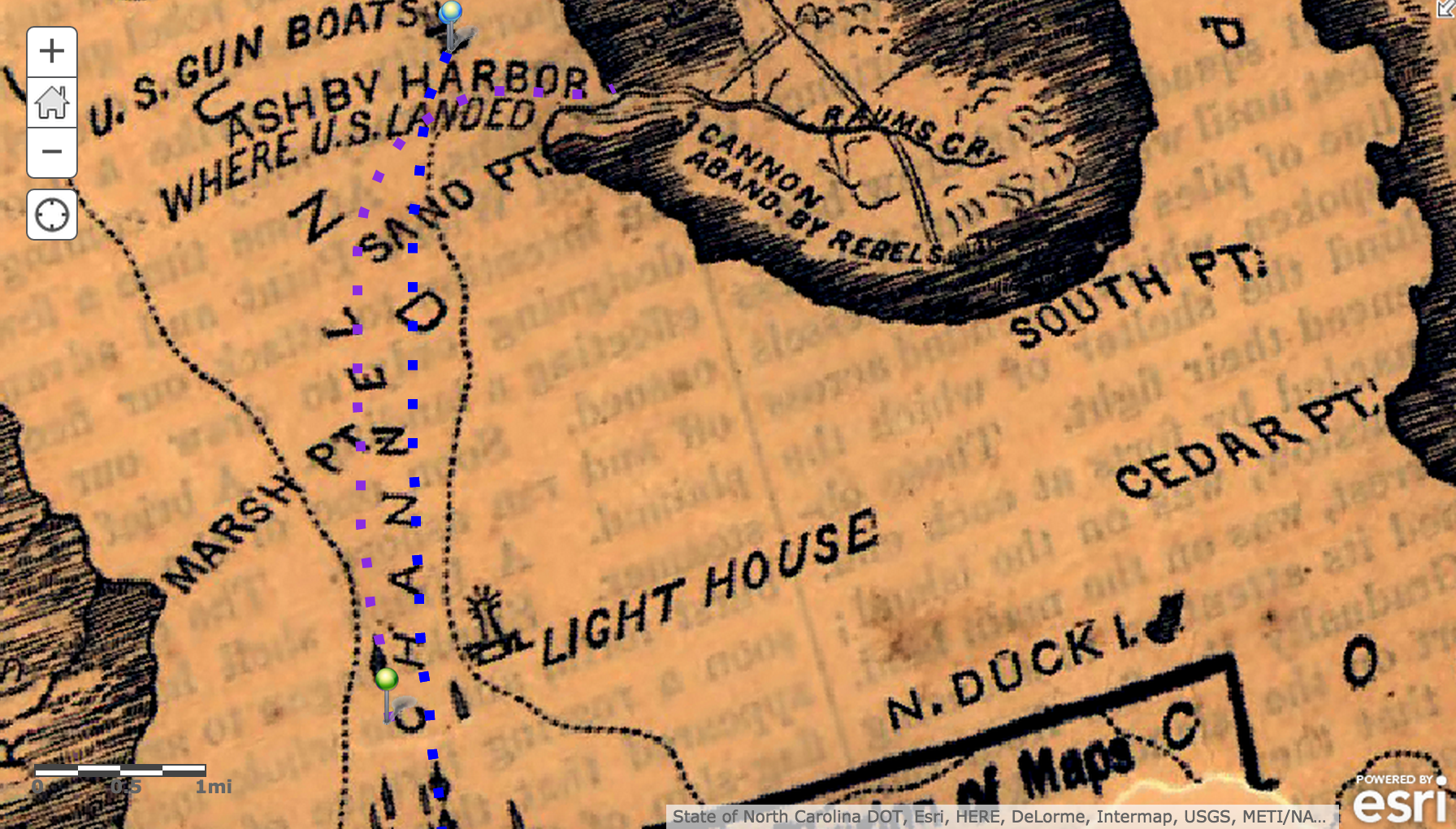
Once I knew I wanted to mark each event on the map, the next question to Linn Mapanswer was ‘how?’  I determined that by using icons available in the map notes feature of ArcGIS, I could create nodes on the map that had a visual relation to the event that it represented.  I feel that this choice of visual representation helped to keep visual clutter down to a minimum, as the icon was all that was needed to represent each point of interest in the project.

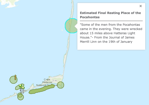
As for the maps I selected, the map of the Battle of South Mills was an obvious choice.  It allowed me to place mid-battle nodes in proper places relative to each other and to the bigger overall scale of the battle.  The pre-battle events were not nearly as location-specific, and so a less detailed map of a larger area was needed.  In this case, the other map I chose for those elements was the North Carolina east coast map.

While I was analyzing the differences between the two writings at each event, I was coming up with different conclusions at each one.  I realized that this was something I also wanted to convey to any viewers of the project, so I decided to include these conclusions along with the explanation of the interesting comparisons in the sidebar slides of the map journal publication.

The Reliability of the Linn DiaryAt each slide of the published map journal, I decided to have the pop-up caption for the current node automatically open.  These pop-ups all contain quotations from the original text which are very helpful for understanding the points being made in each slide of the sidebar.  These automatic pop-ups are also useful during the Battle of South Mills to delineate which node out of the small cluster iscurrently active and being discussed.

After finishing this project, I’m fairly confident that I managed to answer my initial question.  After cross-examination of both works of writing, I’m willing to say that Linn’s diary is accurate enough for us to gather reliable information about the Civil War and the Burnside Expedition from it.  There were differences between the two versions of the story, but most of those are able to be explained simply by the difference in point of view.  There were even a number of occasions where the Linn Diary went into more detail about an event than Burnside’s biography did, leading me to believe that Linn intended for his writings to be a reference for his actions in the Civil War.

In addition, I learned how important it is to check multiple references and points of view when analyzing a particular historical event.  By combining the information recorded in the two writings that I studied, I was able to form a more complete picture of the battle of South Mills than either one could have given me individually.  Every source seems to be likely to include some bit of data that all other references missed, and each bit can be added to the story like a puzzle piece, bringing you closer to fully understanding the event.

Overall, I thought that mapping using ArcGIS was the most effective of the methods we used in class for this project.  Although it didn’t help me to formulate or organize my thoughts about my research question, it did provide me with a way to easily share my results with others.The Reliability of the Linn Diary (1)

Works Cited

Linn, James Merrill. Diary. April 17-19 1862. MS. Bucknell University Archives and Special Collections, Lewisburg, PA.

Ibrahim, Mohamed.  Rowboat Map Icon.  clker.com  Retrieved 3 Dec. 2014

Woodbury, Augustus.  “Major General Ambrose E. Burnside and the Ninth…”  S.S. Rider & Brother, 1867.  As retrieved from course WordPress Site.

Categories
Final Project

Did Linn Have A Major Impact In The Battle of Roanoke Island?

My research question for this project was whether or not James Merrill Linn had a major impact on the Battle of Roanoke Island, or if he just seemed important because of his concise account. To discover the answer to this question, I wanted to compare the movements of Linn to the overall movements of the Union and Confederacy. If Linn happened to be in an important position during a turning point of the battle, he would be considered to have a major impact. I first read all of Linn’s diary entries from February 7th to the 12th, 1862. These entries gave me a picture of the Union’s as well as Linn’s positioning during these dates.

This is a picture of Linn's diary from the 7th.
This is a picture of Linn’s diary from the 7th.

Luckily, these entries had already been transcribed, so it was easy for me to decipher what Linn was saying. Without prior transcription, this process would have been very tedious and time consuming.

Next, I then used ArcGIS to map out the positioning of Linn and the Union, as well as the Confederates. This process was much more difficult because the maps from 1862 are not exact replications of what the land actually looked like. Men who had walked the island drew these maps from hand; therefore, there was slight error when looking at exact positioning of troops.

Screen Shot 2014-12-16 at 7.53.16 PM
This the map “Roanoke1862” with nothing on it. You can see the locations of the gunboats, forts, cannons, etc. very clearly.


To illustrate the different movements of Linn, the Union and the Confederacy, I gave each subject a color. Linn was represented by purple, the Union by blue and the Confederacy by red. This helped show just from a glance at the map that was moving where.

Linn's movements are represented by the purple dotted line. The Union's movements are represented by the blue dotted line.
Linn’s movements are represented by the purple dotted line. The Union’s movements are represented by the blue dotted line.

On the positive note however, these maps did provide a unique look into what the soldiers were seeing in 1862. This is very evident in the layer “Roanoke1862” because the locations of the ships, forts and guns were drawn onto the map. This especially helped the mapping process because it gave me the locations of different Union soldiers that Linn left out in his diary. For example, in the map below, you can see exactly where the Rebels surrendered. In Linn’s diary, he fails to mention the location of where the Rebels actually surrendered, just the location of himself when he heard the news.

Looking at the blue stickpoint, you can see where the Union takes over the battle. Looking at the blue rectangle, you can see where Linn's regiment was located.
Looking at the blue stickpoint, you can see where the Union takes over the battle. Looking at the blue rectangle, you can see where Linn’s regiment was located.

Upon completion of the map, I was able to see where Linn’s regiment was located during the actual land battle. This gave me good insight on his regiment’s importance to the battle, and whether or not they achieved any heroic actions. The 51st Pennsylvania (Linn’s Regiment) was located right along side the Rhode Islanders, in the bottom right corner of the Union’s positioning. This was very far away from the Confederate’s battery (as you can see in the map below). Looking closely, one can see that the Pennsylvania and Rhode Island regiments are in fact very close to each other.

The Rhode Islanders are located directly to the right of the 51st Pennsylvania (blue rectangle)

This is vital because Linn points out that much of the Pennsylvania regiment ends up getting intertwined with the Rhode Islanders. Though not intentionally, this is somewhat comical because while the battle rages on up ahead of them, Linn is worrying about which of his men became tangled up with the Rhode Islanders. This in turn supports my hypothesis of Linn not being very vital to the overall battle, he just happened to have a very detailed account.

 It was through the completion of this map that I discovered that all fighting had stopped on February 8th. This was surprising at first because Linn’s diary account of Roanoke Island lasts until the 12th. Upon further inspection, I was able to conclude that after the battle, Linn in fact traveled all over Roanoke Island. Whether he was completing menial tasks for the military, or just relaxing on the shore, Linn paints a picture of what he accomplished after the battle. Due to the fact that he was simply completing menial tasks, I at first did not find his travel on the island important. After looking intently into his positioning however, I realized that Linn was able to see the island in an entirely different way from the Confederates. Being the victor, allows one to really see the beauty of the land he is fighting on. While the Confederates were being shipped to prisoner of war camps, Linn was able to take in just how beautiful Roanoke Island is. He realizes this when sitting on the shore with Jim, George and Gibson, watching prisoners being transported to the ships.

In conclusion, ArcGIS is a fantastic tool to map out the Battle of Roanoke Island, while at the same time, look at the significance of Linn in the battle. I was able to see that while the battle was raging at the Confederate battery, Linn was in fact far behind, trying to assemble lost troops. Also, Linn was not in fact present when the remainder of the Confederate troops surrendered. He was notified by General Foster, who on horseback, ran into Linn and his regiment on their way back from the battery towards headquarters. Both of these examples solidify my hypothesis of Linn not having a major impact on the overall battle. We are assuming he had one because of his very in depth diary.

In order to see my web application click here: http://bit.ly/1wKZsy0


Citations

Linn, James Merrill. Diary. [February 7-12] 1862. MS. Bucknell University Archives and Special Collections, Lewisburg, PA.

 “Map of the Battlefield of Roanoke Id. Feb. 8th 1862 / | Library of Congress.” Map of the Battlefield of Roanoke Id. Feb. 8th 1862 / | Library of Congress. N.p., n.d. Web. 17 Dec. 2014. <http://www.loc.gov/item/99447476/>.

 “Map of Roanoke Island. [February 8, 1862]. | Library of Congress.” Map of Roanoke Island. [February 8, 1862]. | Library of Congress. N.p., n.d. Web. 17 Dec. 2014. <http://www.loc.gov/item/99447479/>.


Categories
Final Project

Linn’s Letters During the Battle of New Bern

03201862a
Figure 1

As my final project for Digging into the Digital, I chose to look at the letters James Merrill Linn wrote home from March 16 to 26, 1862. I chose these particular dates because they are the letters that he sent as the Battle of NewBern was taking place. In the archives, the diary entries that he would have written during this battle are missing. Either they were lost on the way to Bucknell University’s archives, or he did not write in his diary during the battle. Either way, the letters he wrote home are the only pieces of his first hand occurrence of the battle. My research question is “Do the letters he wrote from March 16 to March 26 actually help to make sense of what happened during the Battle of New Bern?

To get the most accurate answer to my research question, I chose to do close reading. I did not think mapping would be as helpful since I was not worried about the particulars of his location, but rather what was said in the pages. I thought that this would be the most helpful because I could compare it to the diary entries before and after the battle, to see if it does accurately fill in what happened during the battle of New Bern. I was given ten letters from the archives to do a close reading of. I transcribed eight letters written to his brother, John that look like the page shown in Figure 1.

I did not find transcribing the pages too strenuous but I did come across a few difficulties in the letters. In one letter, he must have spilled water on the corner of the page because part of the first line was illegible due to

Figure 2
Figure 2

water damage (Figure 2). There were only a few words that I could not decipher. The majority of my difficulties came from words that Linn used that I have never heard before and had to look up, or words that I have never heard in that context before. The most interesting example of this is in Figure 3 where Linn writes, “I have an altered Harpers ferry which is boxed to send from here”. I had never heard of a ferry that you can box and send home before, so I turned to the Internet to do some research on “Harpers ferry”. At first I came up empty-handed, all the sites said was that this was a National Historic Park of a historic town in West Virginia. However, when I added the word “gun” to my search, it revealed that Harpers ferry was the first rifle made by an American armory.

Screen shot 2014-12-16 at 10.08.48 PM
Figure 3

After transcribing the letters, I began to analyze them through TEI. I put the transcriptions into Oxygen and marked them up. We did the same for Linn’s diary entries in the beginning of the year so I was able to compare his letters to John during the battle of New Bern to other diary entries he wrote. While tagging the letters I noticed a few different things than when tagging the diary. I do not think we used the “affiliation” tag at all Screen shot 2014-12-16 at 9.55.39 PMduring the tagging of the diaries. This time around I used it much more often though. Such as when tagging his company, or the rebels, or anything that refers to a formal relationship with a group of some kind. I also used the “state” tag very often this time around. I think this is because the letters he wrote home to his family are much more personal than what he wrote in his diary. Most likely because he wrote this diary for himself for the future, or for the public to read so he doesn’t put more facts into it than his emotions.

The letters he wrote to John are not as factual, although he wrote about the dates a lot. Most likely because Linn constantly wanted his brother to know what he was doing and where he was going. He also wrote more about generals and the men higher up in the ranks, rather than his comrades, unlike what he wrote in the diaries. I think this is because the diaries are for him personally and he knows who the comrades he is writing about are. John does not know the soldiers fighting alongside James, so he wrote more about the men who tell him and his comrades where to go and what to do. For example he never once mentioned his friend and fellow soldier Beaver in the eight pages that I transcribed, while in the diary he talked about him more than anyone else. Linn wrote about home much more often in the letters than in the diary. He talked about sending relics home, like an altered Harpers ferry, sending money home, and the letters he receives from his family. One part that I found very interesting was when he wrote, “My don’t Annie or Laura write. I have not received anything from them for a long while. I am glad the old shop is gone, though I think you let it go cheap”. In all the diary entries I read, he barely mentioned his sisters, but in a letter to his brother he did. Also, he wrote of events going on at home, something he would rarely do in the diary entries.

Since his diary entries are much more factual than the letters this might seem unfortunate because I am trying to see if the letters written in this time period fill in what happened at the battle of New Bern. I do not have as much information as I would have in a diary entry about this battle, because he writes more about what is affecting him in the battle, and especially the annoyances. One was when he “loaned a pair of my boots to a little Jew belonging to my company, but he disgraced them by blacking out in the battle”. Fortunately, we do have facts about the battle besides through these letters to John.

03161862a
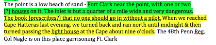
The first two letters, on March 16, were solely focused on the events that unfolded during the battle of New Bern. These letters were not to his brother John, but to a newspaper from his hometown of Lewisburg, called the Star & Chronicle. Captain Hassenplug asked Linn to forward to the newspaper the casualties, loss, and present state of his company. Linn wrote that more have died of disease than have been killed in battle. He also wrote of their advances, attacks, and retreats. On the top of one of the pages Linn wrote “Recapitulation” and gave a summary of who dies, who transferred, who was discharged, who deserted the company, and who was wounded and where they were hurt. He even dedicated a whole paragraph to experiments that him and his company performed in light of the sentence “I have often been reminded of the remark we often hear that it is a wonder so many escape”. Linn thought the newspaper would find their experiments of firing funs at different ranges, and the accuracy of the guns to be interesting.

Ultimately, transcribing Linn’s letters during the battle of New Bern did help me to comprehend the events that unfolded as Linn and his company were in the battle and the aftermath of it. Close reading allowed me to understand what happened during the battle, and also to look at how Linn wrote his letters compared to in his diary. I thought that this project was extremely interesting, and I enjoyed transcribing the letters to figure out how Linn wrote his letters home. It was also very fascinating to read the letter to the Star & Chronicle because it is very different from everything we have looked at in class. Overall, this project allowed me to have a better understanding of the battle of New Bern, and Linn’s writing techniques.


Links to my marked up files:

http://www.students.bucknell.edu/projects/HUMN10002/Wigginton/content/Wigginton_final.xml
http://www.students.bucknell.edu/projects/HUMN10002/Wigginton/Wigginton_file.xml


Works Cited

Linn, James Merrill. Letter to Star & Chronicle. March 16, 1862. MS. Bucknell University Archives and Special Collections, Lewisburg, PA.

Linn, James Merrill. Letters to John. March 19-26, 1862. MS. Bucknell University Archives and Special Collections, Lewisburg, PA.

Linn, James Merrill. Diary. March 12, 1862. MS. Bucknell University Archives and Special Collections, Lewisburg, PA.

Linn, James Merrill. Diary. March 24, 1862. MS. Bucknell University Archives and Special Collections, Lewisburg, PA.

Categories
Final Project

Annapolis to Roanoke: The Troubled Naval Voyage of the Burnside Armada

The Movement of General Burnside’s Armada

http://bit.ly/1vWDVP6

When I started this project, I knew I wanted to talk about Linn’s naval travel, but I was unsure about what specific aspect would be most interesting. My research question was how did naval warfare effect the way that the Civil War was fought, and how did the weather, tides, wind, and other nautical issues effect the way that the war played out. The answer, however, was hidden deeper than I expected. In order to start teasing out the answers to those questions, I began to read through both the Linn diary from January 6th to February 1st and the 3rd and 4th chapters of the Burnside Diary, highlighting things that were related to naval movement, a struggle that they faced while on the water, and anything that I thought could be added to my map to further my story. Both accounts go into incredible detail about the terrible struggles they faced while on these ships, and my fear changed from not knowing what to talk about to not knowing how to pick out the best information and represent it on my map. My next issue was going to be finding what could be depicted as text and what could be added as visuals. After highlighting some sections of all of the texts, I went back through and changed the color of highlighted sections to green that I thought could be represented with symbols on my map.

A sample of my highlighting of the journal

As I continued to do this, I complied a sort of relative timeline, which was, at its core, chronological, but at the same time was not necessarily linear. I found that although information may not be grouped together in the journals, adding it together on my map would allow better understanding of how issues related to nautical travel harassed them during their passage. After moving all of the information from the highlighted journals to the progression of the story that I wanted to tell, I found that I had both information that was clumped linearly and information that went together best when pulled from different areas and presented together.

An example of non-linear information that helps my story when clumped together
An example of non-linear information that helps my story when clumped together. In this case, issues caused by large waves
An example of a section of my linear timeline, where it made sense to present the data chronologically

Unable to find a true ending in the information that I had, I decided to continue on in the Burnside Biography, reading the 4th chapter, when I had initially intended to just use the 3rd, and decided that the perfect ending for my story was when they disembark from the Cossack and arrived at Roanoke. Then, I went onto my map and went through my new “storyboard,” adding map notes in places where I thought they would better represent an ideal better than just pure text. I broke these up into several different layers so that I could isolate the notes that represent different types of events, obstacles, and movements.

The different layers of my map notes

Then, I started to move the rest of my story into the panels, while trying to connect the images on my map to the writing on the panels. As I continued to work, my idea of how I was going to represent my story changed again, and I put different pieces of information where I thought they fit best, not necessarily where they landed in the story. After looking over what I had added and what I had left out so far, something that I found that I had not added were a lot of the direct quotes from the journal. Although I had used these quotes as evidence for some of the text in my side bar, I thought that adding the first hand perspective of these soldiers would strengthen my argument. In order to do this in a matter than continued my exploration of combining visual and textual aspects, I decided that the best place to include these quotes was in the bubbles of the map notes. By adding the quotes to these notes, I hoped to allow the reader to draw a deeper understanding of both what these visuals truly represented and how they connect to the writing in the side bar.

An example of the link between my quotes and writing
An example of the link between my quotes and writing.

The quotes also proved helpful in other ways, as the combination of quotes, historical maps, and the distance indicators on the charts allowed me to estimate several locations, such as the wreckage of the Pocahontas. In the journal, Linn describes the wreckage to be 15 miles above the lighthouse, so using the distance measures on the chart I literally used a note card to measure out 15 miles and guess where the wreckage could be.

An example of how quotes helped me create links to visuals

Because I had to estimate a lot of the locations, using bubbles and free form areas seemed like the best option because it allowed some error in my approximations. The intersection of visuals and text turned out to be one of the hardest aspects, as representing a complex story through multiple different outlets is never easy. As things began to come together, I looked back over what I had done to see if I thought it presented my story well. Although I do believe that there are some limitations to the ArcGIS software, I think that there was no other medium that could present my story in a better way. By integrating visuals and text, I was able to show the audience the movement of the ships, key points of interest, projected locations of different anchorages, wrecks, and lighthouses, as well as explaining the story of the armada and the struggles they faced. A perfect example of this integration is my work on the “swash,” which was represented with a combination of quotes, map notes, text in the side bar, and an additional historical chart.

Screen Shot 2014-12-16 at 2.45.46 PM
An example of how the integration of text and visuals allows for a deeper understanding

Although all of this process may seem important, the building blocks of what of my successful story erupted from the storyboarding process. By laying out what I wanted to say, it allowed me to see all aspects of my thoughts, and manipulate them in the easiest way for my audience to understand. The image that my work had created said less about how naval warfare affected the Civil War as whole, but endless information on how the natural struggles of naval travel inhibited the travel and success of Burnside’s armada, and additionally, how the weather and its associates, such as wind, current, tide, waves, and fog, affected their movement and the advance of the armada as a whole. The data projected a story about nature, whether it be the land itself or the weather, and its effect on travel, and less about the war and the actual battles. The ships constantly had to stop sailing because of thick fog, lost contact with each other due to heavy winds and large waves, and in some cases, the ships were wrecked due to any number of reasons including being stuck on sand bars because of wild tides, thrown into each other by waves, and having water overflow over the sides while in the valley between waves. The Civil War was a dangerous era in naval travel, mostly because of the lack the technology we have today, and the Burnside Armada would have faced issues even in the most spectacular of weather. However, because they faced one of the worst storms in years, the struggles associated with naval travel were increased exponentially. This project allowed me to foster a deeper understanding of both naval travels during this time and how drastically weather conditions can alter the success of a voyage.

Bibliography 

Foster, John G. Sketch Showing Route of the Burnside Expedition [to Roanoke Island, N.C., February 6, 1862]. Digital Image. Digital image.Library of Congress. Washington, Government Printing Office, 1866. Web. 12 Dec. 2014. <http://www.loc.gov/resource/g3901s.cw0317120/>.

Hatteras Inlet Map. Digital image. Sons of the South. N.p., n.d. Web. 12 Dec. 2014. <http://www.sonofthesouth.net/leefoundation/civil-war/1862/february/hatteras-inlet-map.htm>. I found this map inside of a Harper’s Weekly Civil War newspaper from February 15th, 1862.

Linn, James Merrill. Diary. January 6th– February 1st 1862. MS. Bucknell University Archives and Special Collections, Lewisburg, PA.

Major-General Ambrose E. Burnside and the Ninth Army Corps: A Narrative of Campaigns in North Carolina, Maryland, Virginia, Ohio, Kentucky, Mississippi and Tennessee, During the War for the Preservation of the Republic. Chapters 3-4. Augustus Woodbury, 1866

“Map of the North Carolina Coast.” Extract from Harper’s History of the Great Rebellion, Feb. 1862, p. 243. University of North Carolina at Chapel Hill. http://dc.lib.unc.edu/cdm/singleitem/collection/ncmaps/id/887/rec/26

United States Coast Survey. Preliminary Chart of Hatteras Inlet, North Carolina. Digital image. Library of Congress. N.p., 1862. Web. 12 Dec. 2014 <http://www.loc.gov/resource/g3902h.cw0316700/>.

Categories
Final Project

Linn vs. Third Party Sources: The Battle of South Mills

Was James Merrill Linn accurate in his descriptions of his experience in the Battle of South Mills?

The Battle of South Mills

My research question was to find out if James Merrill Linn’s diary transcriptions were a legitimate primary source of information on the Battle of South Mills. To give background information to my audience, I started with my own diary entry date of April 17-18,

Layers from my previous map

1862. I added these map notes to my new map of the Battle of South Mills. During this time, Linn left New Berne, stopped at Hatteras on Roanoke Island, and left for Elizabeth City. This is where I used transcriptions from Julia and Riz, who transcribed the actual battle. Using arcGIS, I mapped out exactly what Linn was writing to the best of my abilities. I used the color green to document anything Linn wrote in his diary to keep it separate for the next step in my research project. During this segment, I did not look at outside sources, besides a couple maps, in order to keep myself zoned in on Linn’s account of what was happening.

Working on web map
Working on Web Map

After mapping out Linn’s version of the Battle of South Mills, I searched for third-party sources that could give me more of an idea of what happened. Using objective sources allowed me to focus on the big picture of this battle and not just what Linn wrote in his diary. When utilizing these sources, I focused on the Pennsylvania 51st Regiment. This was Linn’s regiment, so I assume Linn was with these other soldiers. Gaining more knowledge about the Linn regiment’s whereabouts during this battle made allowed me to gain more insight to what Linn could have been talking about. Also, I wanted to contrast what Linn claimed in his diary to what these other sources claimed. I also mapped out the third-party’s account of the Battle of South Mills and the Pennsylvania 51st Regiment. When mapping this out on arcGIS, I used a new layer and used the color yellow to make all of the pushpins, lines, arrows, etc. This allowed me to see clearly both accounts of the Battle of South Mills.

Finished Map (Showing Green and Yellow)

When the Battle of South Mills was mapped out according to both perspectives, I created a web mapping application. Here, I chose the story template. At first I had a few slides to show the background information on the battle. Once I got to the actual battle, I switched between Linn’s claims and the third-party source’s claims. I utilized the zoom tool and tried to make this part of the project the most user-and-reader friendly. I added pictures of some of the maps that I found on my outside sources that really helped me visualize this battle. Because it happened over 150 years ago, there are not many official accounts of this battle. Technology was not exactly up to par. However, studying many hand-drawn maps of the Battle of South Mills allowed me to get a pretty good idea of how this battle played out.

Working on Web Mapping Application

I decided to narrow down my focus to just actions Linn and his regiment took. I did not want to complicate this research question by adding in emotions, causalities, etc. I took a very objective view while mapping out the Battle of South Mills. This made everything much cleaner and efficient when using the web map and later the web map app. Another “blessing” to me was a website Riz found on the internet called “Battle of South Mills.” It had an abundance of hand-drawn maps of the battle. Also, it was interesting to see some of the artifacts of the battle. Another person’s perspective I payed close attention to while mapping the third party sources’ version of the battle, was that of Lieutenant Colonel Bell. He referenced Linn’s Regiment, Pennsylvania 51st, many times. Whenever I saw something that mentioned Linn’s regiment I was payed extreme attention to it.

Finished Web Mapping Application

Ultimately, arcGIS was a great tool to use to map out the Battle of South Mills. I think it is very user-friendly and anyone would be able to use the web mapping application. I was able to take James Merrill Linn’s diary entries and compare them to third party sources to see his accuracy. At the end of this project, I was not able to completely decide if Linn is an accurate historical storyteller, because I only researched one battle. In my case, I think Linn was a somewhat reliable source. Besides for some minor contrasts in documentation of the battle, it is hard to tell which source was correct. I was only able to find one website that had other sources and account of the Battle of South Mills. I am not even sure how factual that website is. My research question could not sufficiently be answered with this one project.

Citations

“Battle Summary.” Battle of South Mills. Ed. Bruce Long. 10 Apr. 2010. Web. 14 Dec. 2014.
Civil War Cannon. Digital image. Mediad.publicbroadcasting. Web. 16 Dec. 2014. Linn. Digital image. Diane Jakacki. DianeJakacki.net. Web. 16 Dec. 2014.
Civil War Fence. Digital image. Big Stock. Web. 16 Dec. 2014.
Currituck Beach Lighthouse. Digital image. Currituck Beach Light. Web. 16 Dec. 2014.
Currituck Courthouse. Digital image. Appox. Web. 16 Dec. 2014.
Cypress Swamp Along Pasquotank River. Digital image. Champiii. 5 May 2014. Web. 16 Dec. 2014.
“Eastern Coast.” Eastern Portion of the Military Department of North Carolina. S.l. 1862. Print.
Hatteras Island. Digital image. Ocean Front Hotels. Web. 16 Dec. 2014.
Historic Old Jail in Currituck. Digital image. Albemarle Commission. Web. 16 Dec. 2014.
Mouth of Pasquotank River. Digital image. Api.ning. Web. 16 Dec. 2014.
Museum of the Albemarle. Digital image. Battle of South Mills. Bruce Long. Web. 16 Dec. 2014. Operations in North Carolina. Digital image. Battle of South Mills. Bruce Long. Web. 16 Dec. 2014.
Shenandoah 3. Digital image. Tom McMahon. Web. 16 Dec. 2014.
Sneden, Robert K. “Plan of Battle of South Mills.” 1862. ArcGIS. Web. 16 Dec.
2014.
“South Mills Battle.” ArcGIS. Web. 16 Dec. 2014.
The Battle of Camden. Digital image. Battle of South Mills. Bruce Long. Web. 16 Dec. 2014.
The Battle of Camden: Plan of the Battlefield. Digital image. Battle of South Mills. Bruce Long. Web. 16 Dec. 2014.