Categories
Final Project

Path to Freedom

http://bit.ly/1w0gpkm

For the Final Project, I chose to look into the 19 slaves Linn encountered on February 2, 1862. In his diary, Linn said that nothing happened except for a small boat with 19 slaves escaped from above Roanoke Island. This pique my interest since slavery abolition is the primary objective of the Union but Linn seems to be unfazed by the sight of 19 escaped slaves. This brought me to my question “how did the Civil War battles affect slavery?” I thought understanding the slaves’ origin, destination, and escape path would help us understand better about their lives hence giving us a better idea of the life of a slave during the Civil War. Depending on the path the slaves took, different difficulties arises.  To map their escape, there is no better tool than GIS. With GIS, I can illustrate multiple layers of informations associated with the escape.


When I started this project, I did not have much information about the 19 slaves. Linn only mention them once in the diary. All I know was that there were 19 slaves including 5 women and a baby and they came from above Roanoke Island. Without actual information regarding the slaves, I was unable to present this in a story format with GIS. This was the biggest struggle I had during this project. Without any information regarding the time and date, I cannot present this in a timely manner. To figure out their path, I have to find their origin and their destination first.

Screen Shot 2014-12-17 at 2.20.46 PM
Norfolk
Screen Shot 2014-12-17 at 2.21.10 PM
Slave Density

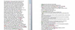
For the origin, I used a layer of the concentration of slaves and the battles fought before February 2, 1862. To come to the Cossack on a small boat, the slaves have to came from a place relatively close to Roanoke Island. There were 19 slaves so they must have all escaped together from a place of high concentration of slaves. Their escape itself is a clue that their origin must have been affected by the war for them to have to opportunity to escape. Using GIS, I can see that Norfolk has a high concentration of slaves and has 2 battles fought near it. After doing some reserching, I learned that during the Civil War, the Confederates used slaves to build their forts. With that, I concluded that the slaves must have came from Norfolk. While working on the forts, the slaves saw the opportunity to escape.

Screen Shot 2014-12-17 at 1.18.42 PM
Map of Underground Railroad and the Directions to Freedom

Professor Jakacki introduced me to the Underground Railroad leading me to find the slaves’ destination. Even before the Civil War, the Underground Railroad has helped freeing slaves in America. Using the Underground Railroad map layer, I could see the directions that the slaves were going in order to attain their freedom. Then, I created a map note for the possible directions that slaves could escape to during the Civil War. To understand the difficulties of each directions, I created a map note for the distance between Roanoke Island and the closest point for each direction. With this, I was able to see the difficulty of each direction in term of distance in kilometer and in days it would take to walk that distance. The slaves had limited resources. They most likely did not have any mode of transportation to travel far so they were trying to get to the North, the direction with the shortest distance. Using the Underground Railroad map layer, I found Wilmington to be the closest Underground Railroad site to where they encounter Linn and his regimen. With this, I can conclude that the slaves were going to Wilmington in order to go to the North.

Screen Shot 2014-12-17 at 3.34.23 PM
Two possible escape paths

With both the destination and the origin, I mapped out the different possible paths the slaves took in order to get to Linn’s location. After their escape, to get to Linn’s location, the slaves must have found a small boat first. If the shore is where they got the boat, they must choose the safest path possible. With 5 women and a baby, they cannot run so they must avoid being seen. They must also avoid conventional roads. They must go through the woods or swamps to avoid getting caught. Using the Terrain map, I can see the swamps between Norfolk and the Shore. Then I created a map note for the those swamps. There are 2 swamps that connect Norfolk and the shore so that must be a possible safe path for the slaves. The second path I found after adding the canals layer to the map. There is a canal that goes from Norfolk to the ocean. This canal goes through a swamp so it might have been safe enough for the slaves to use provided that the canal is big enough for the slaves to use. They must have stole a small boat from Norfolk and travelled down the canal to the Ocean and eventually to the Cossack.

With the help of GIS, I was able to deduce and map the escape path for the slaves with very little information and some research. The 19 slaves have encountered many difficulties in order to attain their freedom. Using GIS, I was able to see and understand the struggles that many slaves faced in their escape. I can see how the Civil War itself affect slavery. War is a double edge sword. Although slavery is the subject of the Civil War, the war itself caused the slaves to be under heavy surveillance. However, we can see that because of the battles, many slaves have to work on the forts providing them an opportunity to escape and gain freedom. This project has helped me to understand the state of slavery due to the Civil War.

Work Cited:

Linn, James Merrill. Diary. [February 2] 1862. MS. Bucknell University Archives and Special Collections, Lewisburg, PA.

“Underground Railroad.” History Net Where History Comes Alive World US History Online RSS. N.p., n.d. Web. 16 Dec. 2014.

Rasmussen, William M. S., and Lora M. Robins. “How Did Slaves Escape?” Virginia Historical Societys Blog. Virginia Historical Society, 20 Oct. 2010. Web. 16 Dec. 2014.

“Underground Railroad Sites.” PBS. PBS, n.d. Web. 16 Dec. 2014.

United States. National Park Service. “List of Sites for the Underground Railroad Travel Itinerary.” National Parks Service. U.S. Department of the Interior, n.d. Web. 16 Dec. 2014.

Categories
Digging Final Project

Was there any new information revealed from Linn’s diary entries on April 18th, 20th and 21st?

As my final project for “Digging into the Digital”, I chose to look at the letters that James Merrill Linn wrote on April 18th, 20th and 21st. To get the most accurate answer to my research question, I chose to do a close reading. My research question is: “Was there any new information revealed from Linn’s diary entries on April 18th, 20th and 21st?” My answer is: Yes, a lot of new information was revealed to me. From reading these letters, I have discovered that he is writing all of this information to send to his brother, on April 18th they were preparing for battle, and that all the fighting occurs on April 19th. In addition, I have learned that that the Confederates won and that on the 21st, Linn is talking about the aftermath of what happened on April 20th.

Close reading helped to reveal that On April 18th Linn and his troops were traveling from Roanoke to Elizabeth City. Linn writes “Lt. Col. Bell called us all up- the officers & told us we should get our men ready to march in an hour back to Elizabeth City. That our safety depended on our doing it that night- that Gen.Reno had reliable information that large reinforcements had been sent for and would be there before morning.” They were all preparing for battle and following Lt. Col Bell’s and the officers’ instructions. On April 19th Reno marched to South Mills. Linn wrote “caps taken off. Then Beaver came in and told me the 21st
had formed & we were to form immediately,” and they were about to begin the fighting. During the battle of South Mills they were fighting the Confederate troops. After a long day of fighting, the war was over and the Confederates had defeated them. On April 21st ,Linn is in the cornfield near Elizabeth City. He writes “ we landed in a cornfield near Elizabeth City some one remarked that was always our luck, but it was not always our luck to have as bright and sunny day as we had now.” He talks about the aftermath of the South Mills battle. He says “One of our boats brought Stitzer, of Co. E. who had been wounded & left, who told us that about 30 their wounded & stragglers had left the battle field at 8 o’clock next morning and came through.” At the end is a note he wrote to his brother, where he says ““I send this act to you. You must keep it strictly confidential.” Linn didn’t want his brother to share all the information he had written about. At this point everything is revealed as to what he’s been doing by his writing; he’s been sending it all to his brother.

I approached my final project in five main steps. First, I copied and pasted the diary entries from the Google document into a word document.


I then decided to mark up the word types with different colors based on whether they were a place, people, object, event, dates, traits and states. People, organizations, things with proper names or titles were blue , places were gray, events were red, objects were green, dates and times were purple, traits were indigo and states were a brownish green. Screen shot 2014-12-12 at 5.38.25 PM

During the mark up process I had a little trouble. For example. I had no idea what cavalry was. I didn’t know whether it was an object, place, or person. So I looked it up on the Internet to find out that cavalry are soldiers who fought on horseback. So I then highlighted the word in blue.

The next step I did was adding tags. I tagged words with : “object type,” “persName,” “roleName,” “placeName,””time,” “role” and “date.”

Screen shot 2014-12-12 at 5.48.14 PM

After I was done with the tagging, I copied and pasted my work into oxygen.

Screen shot 2014-12-12 at 5.43.21 PM

The reason I worked in Microsoft word was because it was easier for me to tag and color code in there as opposed to oxygen. The last step I did was I added page breaks and made sure there was no red coloring and that it was completely green.

I then wrote down new information that was revealed to me on a document beside the one I had previously been working on.


Screen shot 2014-12-10 at 1.26.20 PM

I had to read the entries over a few times to make sure my information was correct. For example, at first I thought that April 21st revealed that the fighting was still going on but then when I went back and read it over again I realized that April 21st was just Linn talking about the aftermath of what occurred on April 19th. I learned other things while using close reading. I noticed that in the beginning he talked about objects a lot. I think he talked about objects because he was surrounded by so many at the time. For example: cannon, shell, ball, red flag and buckshot. Those are all objects that would be present in the preparation for war.

Overall close reading allowed me to understand what was happening in the diary entries and helped me to get the answer to my research question. I enjoyed working with Oxygen because it was very easy to maneuver. Throughout the semester I came to a realization that tagging and color coding were two beneficial techniques in helping to understand the context of Linn’s diary entries. I am glad I chose this as my final project because otherwise I would have never known the ending of Linn’s diary entries!


Bibliography:

Linn, James Merrill. Diary. 4/18, 4/20/ 4/21, 1862. MS. Bucknell University


Works Cited:

Battle of South Mills. (2014, November 29). Retrieved December 2, 2014, from http://en.wikipedia.org/wiki/Battle_of_South_Mills

Categories
Blog #5

Linn’s Journey through the Croatan Sound depicted by GIS mapping

ArcGIS online provides viewers to visualize and interactively map historical events. Working with GIS has given me a better understanding of James Merrill Linn’s locations, battles and overall journey throughout the Civil War. My specific diary entry was dated between February 5-7, 1862, as Linn focuses on his expedition towards Roanoke Island. He starts at Stumpy Point, anchors on the shore of the Island the next day in the Croatan Sound, and then aboard the Spaulding, he travels around the bend of Roanoke Island where a cannonade commences. This cannonade depicts the start of the Battle of Roanoke Island.

Screen Shot 2014-11-19 at 6.46.34 PM
Roanoke Island in respect to Tyrell Shore

Dale Hartman and I hypothesized that Linn misinterpreted his location as he said, “the gun boats has moved up into the Channel between Roanoke Island and the Tyrell shore.” However, as shown to the left, Tyrell shore (shown as Tyrell county on the map) is not in close proximity to Roanoke Island, which is where the battle took place the same day. As Dale and I could stand corrected, we believe that Linn has made an error in his location. By just reading the diary entry, we would have assumed he did actually travel in the Channel between Tyrell Shore and Roanoke Island. However, GIS and maps in general give us the tools and resources to track Linn’s journey throughout the Civil War so we can better understand his locations day by day.

Bodenhamer discusses in his article the significance and consequences of GIS mapping. He says that “making data visual spurred intuitive interpretation- recognition of patterns, for instance- that remained hidden in statistical analysis” (17-18). For our purpose, GIS helped us visualize Linn’s experiences through the Civil War that we could not necessarily realize while just reading his diary entries.  As I mentioned before, Dale and I would not have been able to question Linn’s record of location on February 7, 1862 without using GIS to visualize his path to Roanoke Island.

Bodenhamer also mentions the importance of layers in GIS. He writes, “[g]eographic information systems operate a series of layers, each representing a different theme and tied to a specific location on planet earth. These layers are transparent, although the user can make any layer or combination of layers opaque while leaving others visible” (27). Because maps change over time as scholars continuously make new discoveries, layers benefit the viewer by giving a better sense of historical background of the map at the time. Additionally, layers focus on very specific events in history. For example, the layers “RoanokeRebels” and “Roanoke1862” are directed towards Civil War studies of battles in 1862. The layers are user-friendly and make the map more relevant to the viewer’s field of study.

Bodenhamer raises the point that there are some setbacks to GIS. For instance, scholars are trying to address the issue of “how… we as humanists make GIS do what it was not intended to do, namely, represent the world as culture and not simply mapped locations”(23). In some fields of research, cultural and social differences are critical and should be represented in the maps. However, when tracking Linn’s locations and comparing them to what he wrote in his diary entries, GIS serves its purpose in showing locations and different layers.

GIS has given me an overall better understanding of Linn’s journey throughout the Civil War. GIS and the Map app have essentially brought the diary entries to life and have made it easier to comprehend his path during the war. Here is my final product of Linn’s pathway between February 5-7, 1862:

Screen Shot 2014-11-19 at 7.24.07 PM
Map of Linn’s Journey February 5-7, 1862

Map app link:

http://bit.ly/1uJWaeX


Categories
Blog #5

Experiences while mapping with ArGIS


Unfortunately, I could not glean enough information by just looking at Linn’s diary entries. Using other tools such as ArcGIS was extremely helpful and beneficial. This source revealed how Lynn had a huge role in the Civil War and participated in many significant battles. We also see how he appeared in many different places during the war. ArcGIS showed where the locations were in relation to one another. By seeing a clear layout of the map, I was able to have a better overall understanding of Linn’s participation in the Civil War. ArcGIS has a feature where you can add map notes, which was very beneficial for me. Adding map notes helped to connect the different “clues” Linn was giving. For example allowed me to connect what I knew about the battles of Roanoke and South Mills.

At first, I did not understand the purpose of GIS. I did not grasp the concept of reading words and thinking of them as places. It was extremely frustrating and I was hesitant about the overall process. For example, I was reading about musketry and had no idea how to think of that as being a place on a map. I eventually realized I think of the center location as the medial part of the civil war, so musketry must be located in the middle.

GIS enables students to learn more information and get a better understanding of history. “(Bodenhammer 21) Archaeologist came early to GIS, as well as to other spatial instruments such as global position systems in large measure because it provided a handy and more accurate toolkit for managing their research in familiar but speedier ways” (21). ArcGIS reveals Linn’s participation in the civil war in a more accurate and succinct way.

Visual learning helped me to understand and learn more about Linn in the Civil War. “GIS relies heavily on visualization to display its results” (24). One example of the visualization displayed on the map is the hospital. It was extremely helpful to see where other places were in relation to his location. When Linn was passing by the hospital, I was able to see that he was near fort Hugers and the routes of the escaped rebels.

ArcGIS is a form of close reading. You are visually presented with a map, versus just reading words. Bodenhammerr said “GIS is fundamentally what happens in a geographic space (page 23)”.  Basically, It enables us to take what we have read and be able to visualize it in a way that provides us with more helpful information. By the end of this project, I enjoyed using GIS. It ultimately helped me have a better understanding about Linn’s participation in the Civil War.

Click below to see my final product! :

Screen shot 2014-11-19 at 6.57.38 PM

Categories
Blog #5

Mapping and the Battle of Roanoke

Although it took my a while to understand the program and how it all works, i found mapping to be incredibly useful and it allowed me to pull out a deeper understanding of what my diary entry truly means and how it connects to the war. Mapping itself is a very useful tool, and the ways that we utilized ArcGIS was very interesting. Although it took my a while to understand all the features, it allowed me to create a more interesting and compelling final product. Mapping allowed me to see what my diary was talking about in an easier context, by showing the course of the battle and his movements on an historical map. My mapping assignment allowed me to directly understand what effect my individual entry had on the war. Once i saw the historical map that was geo rectified on the the larger map, i was able to dissect my entry and see how his movements played out. Although it was hard for me to make conclusions from the basic writings of his diary, pulling out key phrases was what helped me in the long run. Little comments such as “He said he had been in pineswamp, but this was worse” and “Here we had to wade a pond up to our middle,” allowed me to make conclusions about where he moved around the map. GIS allows people to make a “more complicated story than traditional methods allowed,” (Bodenhamer) and thats exactly what i tired to do with my map. By combining the historical map and the entry, my story became stronger.

Looking at the historical map, a few things stuck out to me. My map notes below are without the historical map underneath it because it does not show up on my laptop, so i will have to explain. The battery image that comes up on the map is almost identical to the hand drawn sketch from Linn, as well as the location of the swamp in correlation to how he talks about his path to the battery. Although it may have seemed easy to me, its important to realize how perspective plays into all this. As Bodenhamer says, “the same body of water flowing in a channel may be called a brook, stream, or river.” This quote shows the importance of perspective, and it is important because someone else may have interpreted Linn’s writing in a different way from me. I made conclusions about the pineswamp and the pond, but they were not specifically talked about in the diary. Because of this, someone else may look at his path differently than i did.

Screen Shot 2014-11-19 at 5.37.57 PM
my map notes without the historical map
Capture
the battery from my entry


All in all, the practice of mapping allowed me to gain a deeper understanding of the way that Linn records history and how maps can help us gain a better understanding of how history works. By using this software, i was able to figure out “what happens in a geographic space” (Bodenhammerr), which in my case, is the island of Roanoke and specifically my battle field.  Just by looking at the historical map and re reading my diary, i was able to make incredible conclusions about my entry. Mapping for me was useful and interesting, and i think that it is something that i would be interested in pursuing as a final project if i found information that fit well into a mapping situation.

http://bit.ly/1EVI9O8

Above is the embedded code to my map